District Observation Wells
The District well monitoring program began in 2009, and has continued to grow throughout the years due to generous and responsible land owners.
______________________________________________________________________________________________________________________________
Do you have a water well on your property and would like to receive quarterly updates on your water levels? To participate, click here: Well Monitoring Agreement
______________________________________________________________________________________________________________________________
District staff measure and record water levels at these locations quarterly. Submit the above monitoring agreement through our website or mail to PO Box 1749 Springtown,TX 76082, and one of our staff will be in touch.
District Registered Wells
The Temporary Rules for Water Wells require any water well drilled on or after January 1, 2009 to be registered with the District. Furthermore, the District requires owners of all operational nonexempt wells to register their wells and report monthly usage. Owners of any exempt well drilled prior to 2009 may voluntarily register their wells.
To register an existing well, click here: Existing Well Application
Additional questions about maps or data? Email District GIS Analyst jacob@uppertrinitygcd.com.
TWDB: Water Data For Texas
The Upper Trinity has multiple monitoring wells on our site in Springtown, Texas. Other monitoring sites can be found through our monitoring well network, or the Texas Water Development Board’s State Well Database.
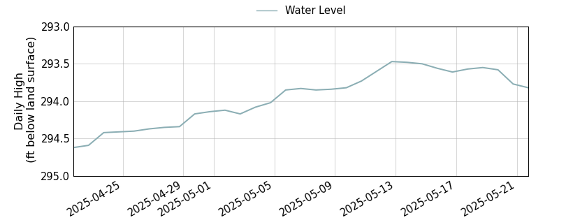
This location is monitored and recorded by Texas Water Development Board (TWDB) staff. The information below was published by TWDB and can be found here.
State Well Number 3242604 is 305.04 feet below land surface on 2015-09-16
Well Information
All data are provisional and subject to revision. The Texas Water Development Board (TWDB) specifically disclaims any and all liability for any claims or damages that may result from providing these data.
| County | Hood |
| State Well Number | 3242604 |
| Status | Active |
| Period of Record | 2002-12-05 to present |
| Entity/Cooperator | Texas Water Development Board |
| Aquifer | Trinity |
| Formation | Twin Mountains Formation |
| Aquifer Type | Unconfined |
| Well Depth (ft below land surface) | 470 |
| Instrument | Float & Weight |
| Transmission | Satellite |
| Groundwater Conservation District | Upper Trinity GCD |
| Groundwater Management Area | 8 |
| Estimated Land Elevation (ft above sea level) | 837 |
| Location (lat, long) | (32.318332, -97.783333) |
| Download Data | csv json txt |